Global and local coordinate systems
General:
Many different global coordinate systems exist and are used.
Local systems use the best approximation of the local true geometrical shape of the Earth.
Global systems, such as WGS-84, approximate the entire Earth.
Transformations are required when comparing (or plotting) data from a positioning sensor on a map that uses a different coordinate system (e.g., WGS-84 X/Y/Z or lat/lon/height on Swiss maps).
The height (altitude) can be geometrical or orthometric (geoid).
Ellipsoids
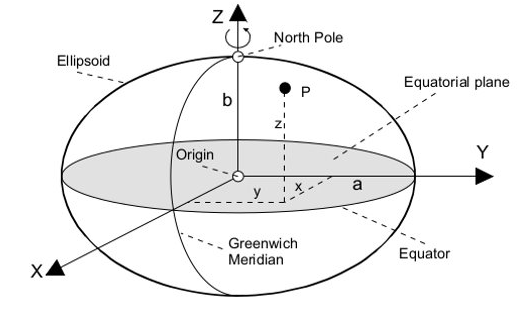
Geodetic coordinates can be expressed by an ellipsoid defined by the parameters:
a: Semi major axis [m]
b: Semi minor axis b [m]
1/f: Ellipsoidal flattening, where f = (a-b)/a [-]
E.g., WGS-84: a = 6‘378‘137 m, b = 6‘356‘752 m, 1/f = 298
Once an ellipsoid is defined, a position on its surface can be defined using a geodetic system. For example:
Cartesian coordinates:
E.g., ECEF (Earth-Centered, Earth-Fixed) coordinates: X, Y, Z [m]

Cartesian coordinates (ECEF) defined by an ellipsoid. Image source
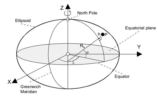
Ellipsoidal coordinates:
E.g., LLH: latitude (phi, φ) and longitude (lambda, λ) in [angle], height (radius) in [m].

Ellipsoidal coordinates (LLH) defined by an ellipsoid. Image source
For more information, please refer to:
Geodetic datum
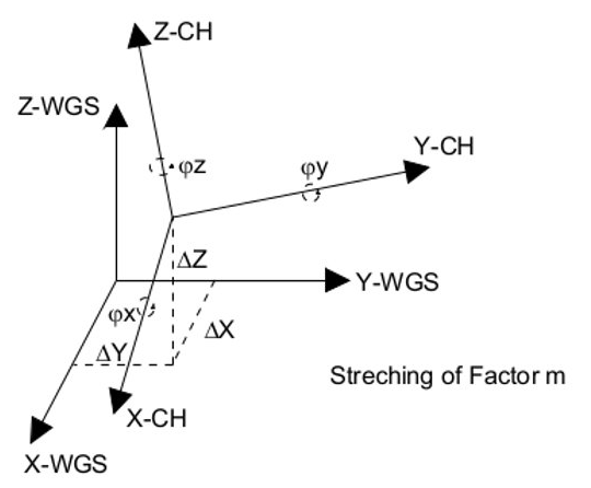
Typically, reference systems are based on local rather than global geocentric ellipsoids. The geodetic datum is the relationship between the local (e.g., the Swiss one) and a global geocentric system (e.g., WGS-84).
The transformation between the two reference systems is defined by:
A "datum shift" in Δx, Δy, Δz [m]
Rotation angles φx, φy, φz [angle]
Scaling factor m [-]
Note that some of these parameters can be zero.

Transformation between two reference systems. Image source
Map projections
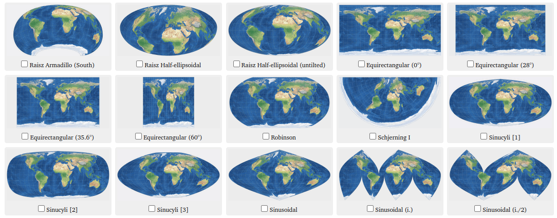
Many different local projection systems exist to generate local and/or global maps. These can be selected in order for the corresponding maps to have properties such as:
Angles preserved on the map.
Distances preserved on the map.
These projections are only valid for a small area (e.g., a small country). Larger countries may use multiple systems for different "zones" (e.g., Poland <https://geoforum.pl/gis/zastosowania>). The Swiss projection is an oblique, conformal cylinder projection (Mercator projection). Note the variation with latitude of represented distances (in degrees or pixels) on the Mercator projection per actual distances (in meters) on Earth surface.

Examples of map projections. Image source
